|
by Madeline Merrill This past weekend, I was one of the many Virginians who spent the majority of their Saturday afternoon outside, and didn’t complain once about the 60+ degree weather. A warm afternoon in February is nothing short of a treat. It was great to shed the heavy layers of winter, get some Vitamin D, and spend time away from artificial lighting, sans gloves and scarves and puffer coats. But warm weather in February is not a win for everyone. On the Eastern Shore of Virginia, residents watch the water line creep upwards, year after year. The Army Corps of Engineers projects relative sea level in Virginia could rise as much as six feet by the end of the century.[1] Much of Norfolk’s infrastructure has been built on swamps and streams, and the land has been slowly sinking for thousands of years. But climate change is also affecting these sea levels. Norfolk’s Deputy City Manager Ron Williams cites that by the year 2100, neighborhoods as much as a quarter mile inland could be inundated or need design changes to protect them from flooding.[2] In recent years, Norfolk has installed road signs that act as “essentially huge vertical rulers” so that people can measure the depth of floodwater at low-lying intersections in the event of a flood.[3] For decades, environmental activists and environmental policy researchers have warned that human carbon emissions would cause land ice to melt, ocean water to expand, and sea levels to rise.[4] Virginia is not alone in its concerns. All along the Atlantic shoreline, cities and ports are witnessing water creep up, inch by inch. New research using GPS and prehistoric data has shown that nearly the entire coast is affected, from Florida to Massachusetts and parts of Maine.[5] However, Virginia faces a unique situation - Norfolk and the larger Hampton Roads area are among the worst-hit parts of the United States. The region is second only to New Orleans, in terms of highest rates of sea level rise. It hosts a significant military presence, with ports and naval bases right on the Virginia shoreline. Hampton Roads has the second largest concentration of military capacity and activities in the United States, and is home to the world’s largest naval base – Naval Station Norfolk.[6] 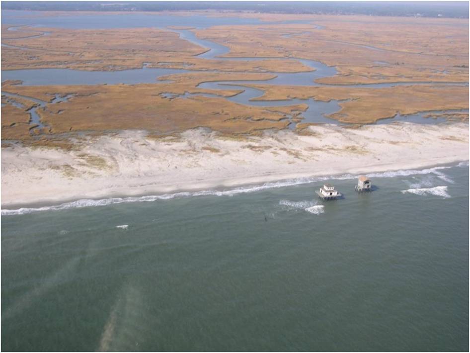 Abandoned houses stranded offshore by rapid shoreline change | Credit: M. Fenster, Virginia Coast Reserve LTER Abandoned houses stranded offshore by rapid shoreline change | Credit: M. Fenster, Virginia Coast Reserve LTER Forty-six percent of the local Hampton Roads economy is supported by Department of Defense spending.[7] Should ports or military bases need to be relocated due to rising sea levels, Eastern Virginia is particularly at risk of severe economic downturn.
What are Virginian legislators and policymakers doing to address the creeping waterline? Virginia has established a revolving loan fund to help homeowners and businesses make changes to their properties in anticipation of sea-level rise - a step the program's advocates say no other state has taken.[8] Gov. Terry McAuliffe signed legislation establishing the “Virginia Shoreline Resiliency Fund.” Senator Lynwood Lewis, a Democrat from the Eastern Shore, sponsored the bill, SB282. The legislation is similar to a program sponsored in Connecticut. However, Virginia’s loans differ from this legal precedent. Virginia will lend funds to citizens not just to deal with immediate flooding threats and damage, but to mitigate future flood damage. What advocates of the program may not know, however, is that the fund has virtually no money, and might not receive state funding for several more years. Right here in Charlottesville, a team of University of Virginia faculty members are helping Virginia’s coastal communities rise to the challenge of encroaching seas.[9] “As a state institution, we have a particular obligation to engage in these issues that are a threat locally, nationally and globally,” said Associate Architecture Professor Phoebe Crisman, who directs UVA’s Global Environments and Sustainability program. Crisman, Ellen Bassett, and Mark White lead the Charlottesville charge to address rising waters in Portsmouth and Norfolk.[10] As our local team of experts survey best practices from around the world, including the Netherlands, and introduce new methods of containing coastal flooding in the Norfolk region, we in Virginia should stop and think twice before celebrating another prematurely warm February afternoon. [1] https://www.pri.org/stories/2016-06-20/us-city-learning-dutch-living-water-approach [2] https://www.pri.org/stories/2016-06-20/us-city-learning-dutch-living-water-approach [3]https://www.nytimes.com/2016/09/04/science/flooding-of-coast-caused-by-global-warming-has-already-begun.html [4]https://www.nytimes.com/2016/09/04/science/flooding-of-coast-caused-by-global-warming-has-already-begun.html [5]https://www.scientificamerican.com/article/sinking-atlantic-coastline-meets-rapidly-rising-seas/ [6] https://www.wri.org/sites/default/files/wri_factsheet_virginia_final.pdf [7] https://www.wri.org/sites/default/files/wri_factsheet_virginia_final.pdf [8]http://www.governing.com/topics/transportation-infrastructure/tns-virginia-revolving-loan-fund.html [9]https://news.virginia.edu/illimitable/commonwealth/saving-virginias-coasts?utm_source=VirginiaHome&utm_medium=referral&utm_campaign=news [10]https://news.virginia.edu/illimitable/commonwealth/saving-virginias-coasts?utm_source=VirginiaHome&utm_medium=referral&utm_campaign=news
0 Comments
Your comment will be posted after it is approved.
Leave a Reply. |